Beginners Guide
Receiving (Live) Weather Data
Weather data, which can be
received live (and free), can be split into several groups :
1.Weather Charts via Short-wave (Marine Fax)
The transmission mode used for weather charts on short wave
are transmit line by line.
To correctly receive the chart you must have
the same drum speed (RPM) (for correct slanting), and the same index of
co-operation (IOC) (for vertical resolution) as the transmitting
station.
Usual RPM speed is 120 with a IOC 576. RPM 60 and 90 are often
in use by CIS stations, also some Charts are transmit with a IOC
288.
Press Photo Fax transmissions use RPM 60 and IOC 352
Weather Charts on Short-wave are transmitted as Frequency
Modulation (FM).
That means that the transmitter is keyed between two
frequencies, which 1500 Hz corresponds for Black and 2300 Hz for
White
For half tone (grey scale) Satellite pictures, the transmitter
frequency shifted between the frequency for black (1500 Hz) and the
frequency for white (2300 Hz).
The difference/2 between the frequency
for white and the frequency for black is called Deviation. The standard
deviation on Short-wave is 400 Hz (2x400=800 1500 to 2300 Hz).
For
Long wave transmissions the standard Deviation is 150 Hz.
To receive Weather Charts on Short-wave you need a Single
Side Band (SSB) Receiver to receive the FM modulated audio
Sub-carrier
Select the Upper Side Band (USB) and tune in the (carrier)
frequency 1.9 kHz lower as listed
The audio frequency output
(Record/Speaker) is then fed to a interface or the Sound Card input, that
converts the different audio frequencies into digital format that can be
processed by the computer.
Automatic Picture Transmission (APT) is used
to enable a fully automated unattended reception of the transmitted
pictures.
At the start of the transmission a start tone is transmitted
for some seconds, which is recognised by the receiving unit.
At the
end of the transmission a stop tone is sent that switches the receiving
unit back to standby mode. See also the HF-FAX
listings or the HF-FAX
schedules. For examples take a look at the Weekly Picture page
Weather Charts have only
Black and White contours, for good resolution 2 Bit decoding is the best
way for clear charts
2. Satellite rebroadcasts via Short-wave
A view stations around the world (USCG, Tokyo, Honolulu,
Taipei and Delhi Meteo) transmit also Satellite Rebroadcasts from the GOES
and GMS Geostationary Satellites.
To receive these grey scale pictures
you should decode them with 8 Bit greyscale. See also the Weekly Picture page
For Satellite rebroadcasts
the standard RPM is 120 and IOC 576.
3. SYNOP Data via Short-wave (RTTY)
Several Meteo stations transmit 24 hour daily Teletype
(RTTY) Synopsis Data on short wave from weather stations around the
globe.
These (5 number) data streams are called as example SYNOP AAXX
or SHIP BBXX and are WMO standard.
To decode the SYNOP data you need a
SSB receiver and also an RTTY decoder which decode the numbers into clear
text or to convert graphical maps. See also the SYNOP
page
4. NAVTEX (RTTY) on 518 kHz
For ships operating in coastal areas, Marine Safety
Information (MSI) is disseminated using the international NAVTEX system
transmitting on 518 kHz (SITOR-B)
NAVTEX is an internationally standard
method of receiving notices.
The service uses a single frequency with
transmissions from nominated stations within each NAVAREA being arranged
on a time-sharing basis to eliminate mutual interference.
All necessary
information is contained in each transmission.
The power of each
transmitter is regulated so as to avoid the possibility of interference
between transmissions.
Each NAVTEX message broadcast contains a
four-character header (B1 to B4)describing:
First character (B1) =
station ID
The transmitter identification character (B1) is a single
unique letter which is allocated to each transmitter. It is used to
identify the broadcasts which are to be accepted by the receiver and those
which are to be rejected.
In order to avoid erroneous reception from
two stations having the same (B1) character, it is necessary to ensure
that such stations have a large geographical separation.
NAVTEX
transmissions have a designed range of about 400 nautical miles.
Second character (B2) = message content (subject indicator
characters)
The subject indicator character is used by the receiver to
identify different classes of messages.
The indicator is also used to
reject messages concerning certain optional subjects which are not
required by the ship (e.g. OMEGA MSG if the ship is not fitted with an
OMEGA receiver)
Third and forth character = message serial number
To decode the NAVTEX data you need a SSB receiver and also
an RTTY decoder which decode the data into clear text. Navtex broadcasts
are all in English on SSB on 518 kHz. What's the best you can do to
receive a message and what do you need for receiving it. More detailed
info’s on the NAVTEX
Page. See also my NAVTEX
Listings
WEFAX TRANSMISSIONS
WEFAX stands for Weather Facsimile and is similar to other types of fax transmissions. There are currently three different countries that transmit WEFAX, these are the US (GOES), European (Meteosat) and Japanese (GMS ) satellites.
WEFAX is a way of getting monochrome analogue picture information through a standard voice audio channel. The signal varies rapidly in
frequency and is sampled from a few hundred times per second to a few thousand times per second depending on the type of WEFAX transmitted.
The varying tones correspond to varying shades of gray that the satellite sees as it scans the earth.
The earth is scanned every half-hour where the raw data is transmitted to a receiver station requiring a 60' dish with sophisticated computing equipment.
The data is reformatted in real time with political boundaries added and transmitted to the satellite where it is retransmitted back to earth at 1691 MHz. A 1691 MHz down converter and a small dish antenna are required to receive WEFAX.
The WEFAX images received are cut into 800 by 800 pixel sections and annotated. The 800 lines of an image each take 250 ms to transmit; hence a whole picture takes about three and a half minutes to receive. A schedule is published detailing what pictures are transmitted at which times and on what channel
IMAGES Weather satellites do not have sensors that cover the visual
spectrum to produce true colour images. They have multiple image sensors
onboard that covers the red portion of the spectrum (visual) to the
Infrared (IR). Visible satellite images provide information about
the observed cloud cover.
Meteorological satellite
radiometers measure outgoing radiation through broad spectral intervals
called atmospheric windows. Radiation passes here without severe
attenuation by the intervening atmosphere.
Visible images are produced by reflected solar radiation
that directly illuminates the earth; this is only available for daytime
weather watching.
Areas of white indicate clouds while shades
of gray indicate clear skies, this is because thicker clouds have a higher
reflectivity and appear brighter on a visible image than thinner
clouds
IR imaging is needed, as weather watching is
essential day and night. Colour enhanced infrared satellite images are
measurements of temperature thus only the differences in temperatures are
visible. In an IR image darker is warmer and lighter is colder. Low clouds
tend to be warmer than higher clouds. Most satellite images on TV are
IR.
Water vapor images are useful for pointing out regions
of moist and dry air.
This provides information about the swirling
troposphere's wind patterns and jet streams. Darker colours indicate drier
air while moisture in the air is seen as white.
5. Geostationary Satellites (APT-WEFAX/PDUS)
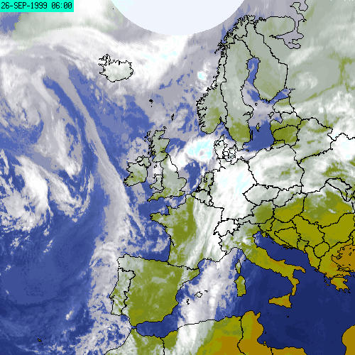 |
The European Geostationary satellite currently transmitting to us is Meteosat 7.
This satellite orbits the Earth at approximately 36,000 kilometres above the Earths surface and appears to be stationary over a specific point.
The Meteosat satellite is at 0° longitude above the equator and sees the same view of the globe as this.
From the point of working with satellite data, data from Geostationary satellites is superior in that it can be received according to a timetable where a new image is transmitted every 4 minutes.
Every half an hour the globe is scanned and the data is split in to smaller blocks and sent down according to a dissemination schedule.
Images covering the European segment are sent down every half an hour.
Because the satellite is stationary it is possible to create an animation of images as they are received and here explore the movement of weather systems.
These images of the entire visible half of the globe are transmitted on Channel 2 These are called Total World images - coded as CTOT, DTOT and ETOT respectively.
The Total World images are cut into 9 segments for transmission at higher resolutions.
The segments are transmitted every 4 minutes on Meteosats Channel 1 frequency
These are coded as C1; C2 ... ; D1; D2 ... ; E1; E2 ... for Visible, Infra Red and Water Vapour images respectively.
In order to receive data from Meteosat you will need to have a fixed dish antenna mounted with a clear facing aspect to 0 deg.
This is connected to a receiver and then to a PC running a suitable APT software package.
Geostationary satellites can see each other and so can transmit data from one to another.
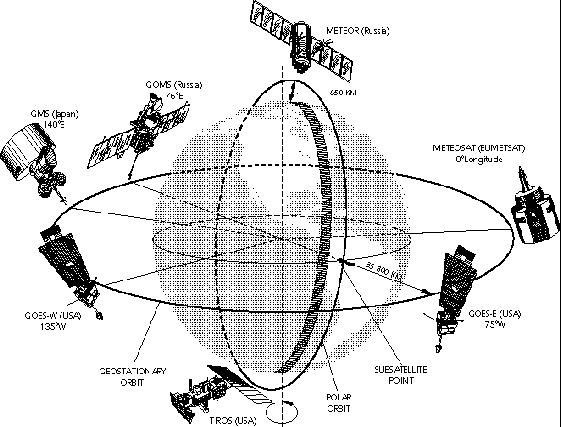
From Meteosat we can also receive retransmitted data from the Russian satellite GOMS, the Japanese satellite GMS and the American satellite GOES East which gives us coverage around the world.
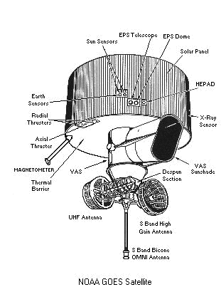 |
Geostationary satellites provide the kind of continuous
monitoring necessary for intensive data analysis. The images produced by
these satellites are processed in real time, distributed in digital form
to forecasting centres for archival and to the media for weather
forecasts.
The majority of the geostationary weather satellites
have the primary mission of imaging their hemisphere. The satellites spin
on their axes at approximately 100 revolutions per minute (r/min),
providing the horizontal scanning, while a motorised mirror with a period
of approximately 20 minutes is used to provide the vertical
scanning.
This data is relayed back to earth in a very high-density
digital format that requires specialised equipment for reception and
display. High-
speed computers process this image data on the ground;
these provide two different functions. First, the original data is
retransmitted in a 'stretched' digital format.
Secondly, they
sector the data into individual quadrants, then relay these images in
analogue form back through the satellite as part of the Weather Facsimile
(WEFAX) program.
The primary instruments on board are the Imager
and the Sounder. The Imager senses radiant energy and reflected solar
energy from the earth's
surface and atmosphere.The sounder provides
data for vertical atmospheric temperature and moisture profiles, surface
and cloud top temperature, and ozone distribution.
Imagery obtained
by these satellites are used to track cold fronts, to monitor severe
convective storms, to identify and track volcanic ash clouds, to derive
winds from the observed motion of clouds, to estimate rainfall during
thunderstorms and hurricanes for flash flood warnings. They are also used
to estimate snowfall accumulations and the overall extent of snow
cover.
Of immediate importance to Australia is Japan's current
operational satellite, this being Japan's Geostationary Meteorological
Satellite (GMS) series. Under a bilateral agreement with Japan, Australia
has special supplementary real time access to GMS imagery and
products.
Japan runs GMS-5, located at 140 degrees east longitude
and covers East Asia, the Western Pacific and Australia.
Automatic Picture Transmission (APT) is used by Satellites
to enable a fully automated unattended reception of the transmitted
pictures.
At the start of the transmission a start tone is transmitted
for some seconds, which is recognised by the receiving unit.
At the
end of the transmission a stop tone is sent that switches the receiving
unit back to standby mode. See also the WXSAT pages,
Weekly Pictures or the Supplier
pages
The Meteosat and other Geostationary satellites
(GOES/GMS/GOMS) have also Digital High Resolution transmissions, which
needs special equipment.
 |
6. Polar Orbiting Satellites (APT/HRPT)
It is also possible to receive data from various Polar
Orbiting satellites and this may well be the cheapest option, but it does
have limitations.
The hardware for this consists of a VHF antenna (the
most popular being a crossed dipole), a receiver (137 MHz band) and a
suitable software package for displaying on a PC.
Satellites in Polar
Orbit are much closer to the Earth surface (around 800-1000 km) and so the
image scanned is of a much higher resolution.
The satellite scans what
is directly beneath it so in higher latitudes the curvature of the Earth
does not pose a problem of the data being invalid, as is the case with
Geostationary data.
The NOAA Polar Orbiters are placed in a sun
synchronous orbit which means that they will pass overhead at
approximately the same time of day.
Unlike the imagery from Meteosat
which lends itself to creating animation’s, Polar Orbiter data cannot be
animated easily.
The satellite when it passes may be within view of
your antenna for about 12 minutes but it will not be following the exact
same path overhead and so each captured image will differ.
In order to
receive data from Polar Orbiters your ground station needs to be visible
from the satellite so if you wanted data from other parts of the world you
would either have to take your equipment with you to that part of the
world or swap data with another station. See also the WXSAT pages,
Weekly Pictures , APT, HRPT, LIRT
or the Supplier
pages
The Polar Orbiter satellites have also Digital High Resolution
transmissions (HRPT), which needs special equipment.